


La chapelle Janson

CANON2
User
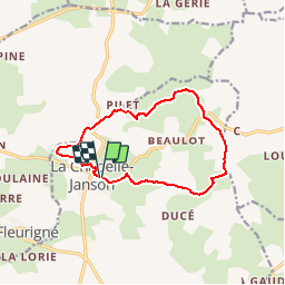

Length
11.4 km

Max alt
243 m

Uphill gradient
216 m
Km-Effort
14.3 km

Min alt
110 m

Downhill gradient
215 m
Boucle
Yes
Creation date :
2019-05-15 13:09:37.977
Updated on :
2019-05-15 13:09:38.051
3h05
Difficulty : Easy

FREE GPS app for hiking
 SityTrail
IGN / Geographical institutes
SityTrail Plus
The world is yours!
About
Trail Walking of 11.4 km to be discovered at Brittany, Ille-et-Vilaine, La Chapelle-Janson. This trail is proposed by CANON2.
Positioning
Country:
France
Region :
Brittany
Department/Province :
Ille-et-Vilaine
Municipality :
La Chapelle-Janson
Location:
Unknown
Start:(Dec)
Start:(UTM)
640913 ; 5356626 (30U) N.
Comments